Operations & Values That Define NORTH SURVEYORS
Serving Maharashtra, Gujarat and Rajasthan with unwavering accuracy, innovation, and trust.
 Where Precision Meets the Map
Specialized surveying across Maharashtra, Gujrat and Rajasthan with accuracy and expertise.
North Surveyors operates across Maharashtra, Gujrat and Rajasthan, delivering tailored surveying solutions to meet local requirements. Our regional expertise, combined with modern tools, ensures precise, compliant, and timely results.
Maharashtra
Comprehensive land and engineering surveys from rural developments to large infrastructure projects.
Mumbai
High-precision urban planning, construction staking, and utility mapping for metro projects.
Rajasthan
Large-scale cadastral mapping, infrastructure layouts, and conservation-focused land surveys.
 Our Mission
The Principles We Stand By
At SURVEYORS, our work is guided by integrity, fueled by innovation, and defined by excellence—ensuring every survey meets the highest standards of accuracy and professionalism.
- ○ Integrity – Upholding honesty in every measurement and report.
- ○ Innovation – Harnessing GPS, drones, CAD, and GIS software for modern surveying.
- ○ Excellence – Committed to precision and detail in all projects.

 Our Values
Driven by Accuracy, Guided by Purpose
Our mission is to shape the future of surveying by delivering dependable results, utilizing the latest technology, and maintaining an unwavering commitment to ethical and sustainable practices.
- ○ Deliver accurate & reliable survey data.
- ○ Support sustainable development through responsible land planning.
- ○ Build lasting client relationships based on trust.
- ○ Integrate innovative methods for improved efficiency.
Our Expertise
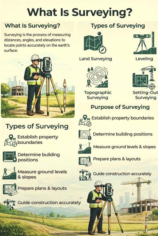
What Is Surveying?
Surveying is the process of measuring distances, angles, and elevations to locate points accurately on the earth's surface. It is the foundation of all civil engineering and land development.
- ○ Land Surveying – Mapping and measuring property boundaries.
- ○ Topographic Surveying – Identifying land features and elevations.
- ○ Leveling – Establishing precise height and gradient checks.
- ○ Setting-Out – Transferring design plans onto the physical ground.
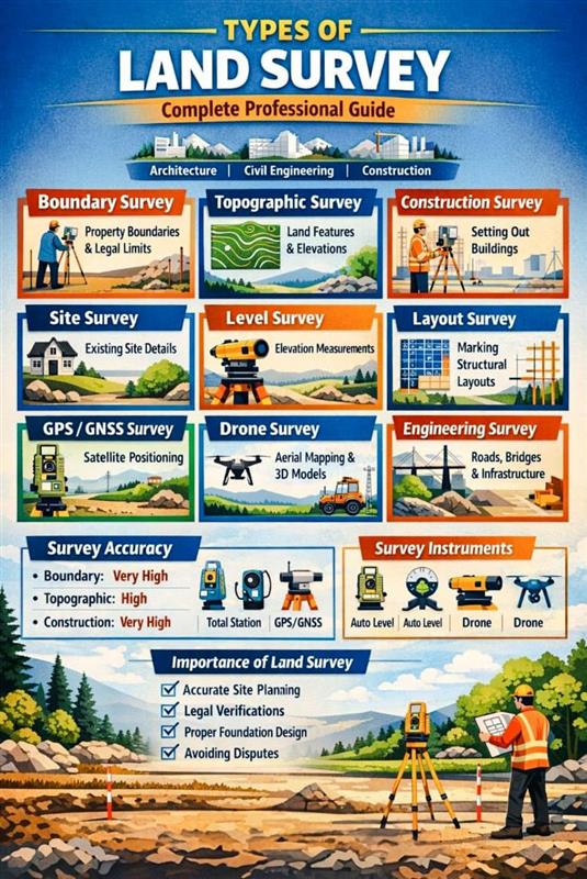 Professional Guide
Complete Land Survey Solutions
We provide a comprehensive suite of surveying services tailored for Architecture, Civil Engineering, and Construction industries, ensuring legal compliance and structural integrity.
- ○ Boundary & Site – Defining legal limits and existing site details.
- ○ Engineering Survey – Specialized mapping for roads, bridges, and infrastructure.
- ○ Modern Tech – High-precision Drone mapping and GPS/GNSS satellite positioning.
- ○ Importance – Accurate site planning, foundation design, and avoiding legal disputes.
Our Expertise
What Is Surveying?
Surveying is the process of measuring distances, angles, and elevations to locate points accurately on the earth's surface. It is the foundation of all civil engineering and land development.
- ○ Land Surveying – Mapping and measuring property boundaries.
- ○ Topographic Surveying – Identifying land features and elevations.
- ○ Leveling – Establishing precise height and gradient checks.
- ○ Setting-Out – Transferring design plans onto the physical ground.
Professional Guide
Complete Land Survey Solutions
We provide a comprehensive suite of surveying services tailored for Architecture, Civil Engineering, and Construction industries, ensuring legal compliance and structural integrity.
- ○ Boundary & Site – Defining legal limits and existing site details.
- ○ Engineering Survey – Specialized mapping for roads, bridges, and infrastructure.
- ○ Modern Tech – High-precision Drone mapping and GPS/GNSS satellite positioning.
- ○ Importance – Accurate site planning, foundation design, and avoiding legal disputes.
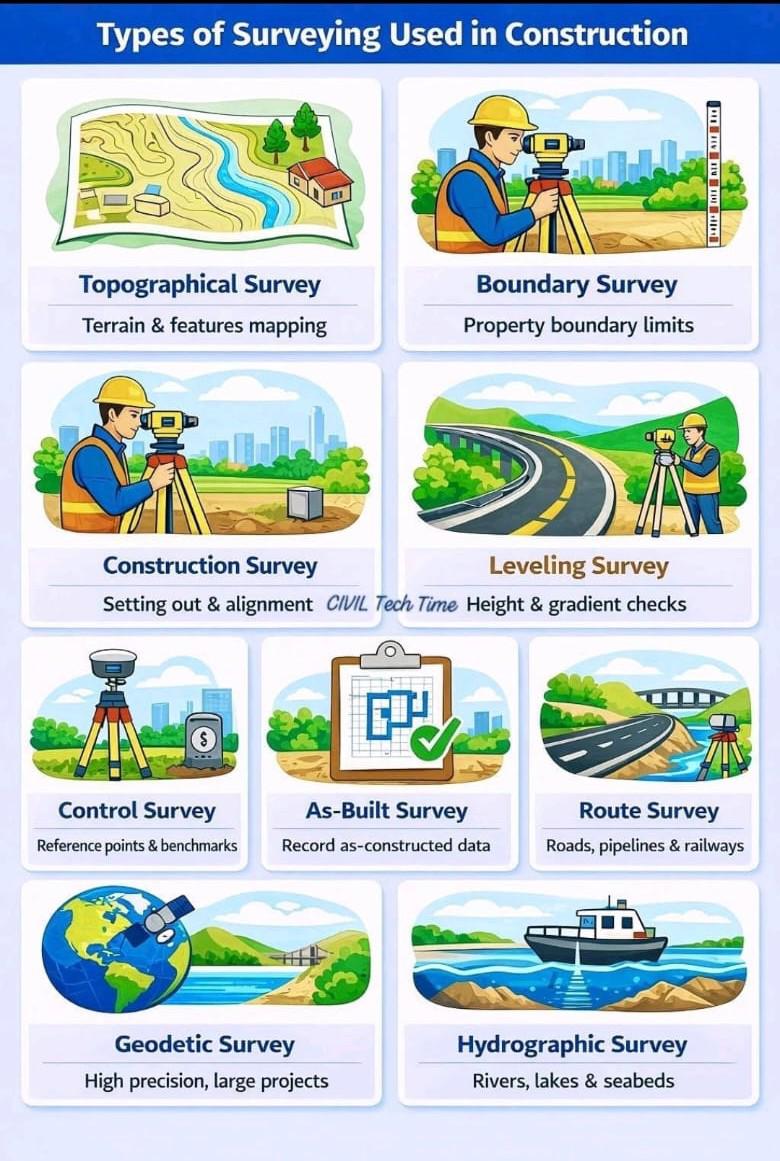
Construction & Infrastructure
Precision in Construction Surveying
Specialized surveying techniques used to guide the construction process from initial ground-breaking to the final as-built documentation.
- ○ Route Surveying – Planning for roads, pipelines, and railways.
- ○ Hydrographic – Specialized mapping for rivers, lakes, and seabeds.
- ○ Geodetic Survey – High-precision measurements for large-scale global projects.
- ○ As-Built Survey – Recording final data to confirm construction matches design.
Testimonials
What Our Clients Say
Our reputation is built on accuracy, trust, and client satisfaction. Here’s what our partners and clients have to say about working with NORTH SURVEYORS.
- Excellent Service: You praised our team’s responsiveness and helpfulness.
- Quality Appreciation: Our services met or exceeded your expectations.
- Effective Communication: You appreciated our clear and timely communication.
Sarika
-
Working quality is Best service forever... Good Communication... Good Quality work... Best person.. My Dear Tushar sir.. & Team... ♥💯
Shaikh
-
Prompt and Professional service.
Friendly and knowledgeable staff particulary Tushar and Team
Naganath Ingale